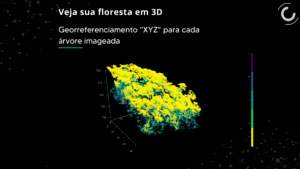

Aiming to promote scale gains in projects in the voluntary carbon market, BRCarbon acquired a new technology capable of mapping and measuring a forest in three dimensions (XYZ) using a drone. The active sensor LiDAR (Light Detection and Ranging) coupled to the drone is what makes 3D mapping possible in the project areas. At these sites, periodic measurements of Permanent Plots are carried out to quantify the growth performance of a planted or native forest. The focus is that the LiDAR + drone remote measurements are additional to the measurements carried out in the field, as already demonstrated by the academic and scientific community. Currently, the quantification of carbon stock and sequestration in trees in a forest is still carried out through the conventional forest inventory. This involves a team of diverse professionals and intense field work, several logistical challenges and even a low sampling capacity. The use of LiDAR comes to add to the forest field measurements, as it provides greater sampling capacity with three-dimensional imaging of areas greater than 200 hectares in a single flyover.
By crossing the data collected remotely with the information collected in the field, the process of forest measurement and quantification of a forest’s carbon stock (forest inventory) gains greater reliability and quality.
In the projects implemented by BRCarbon, the LiDAR + drone system will be used to count the number of trees, XYZ georeferencing of trees, indirect height measurement, canopy diameter and area measurement, identification and quantification of clearings and tree mortality. The information generated through the validation of remotely measured data and in the field will be used to quantify the gain or loss from the forest carbon stock and, consequently, measure and report on the climate impact of the concerned project.
In addition to the three-dimensional point cloud (XYZ), the use of LiDAR + drone takes aerial photographs that generate images with very high spatial resolution, of 50 centimeters in true color (RGB).
To better understand the potential of this technology, watch the video and see a little bit of what’s to come:
Comments are closed.